The first photograph invited the wrong question. From the air, the Patomskiy Crater seemed to be a projectile's signature: a gray ring dropped into the green taiga, remote enough to preserve a cosmic secret. On the ground, however, the structure did not behave like a wound punched downward. It behaved like a pile assembled upward in episodes.
I treated the site as four witnesses who had never compared their stories. The landform described motion. The rocks recorded temperature and fluid. The larches supplied dates. An electromagnetic profile hinted at the buried structure. When I put those testimonies in chronological order, the meteorite became unnecessary. The remaining mystery was more interesting: how could a young, volcano-shaped cone rise through ancient limestone hundreds of kilometers from the volcanic landscape most people would expect?
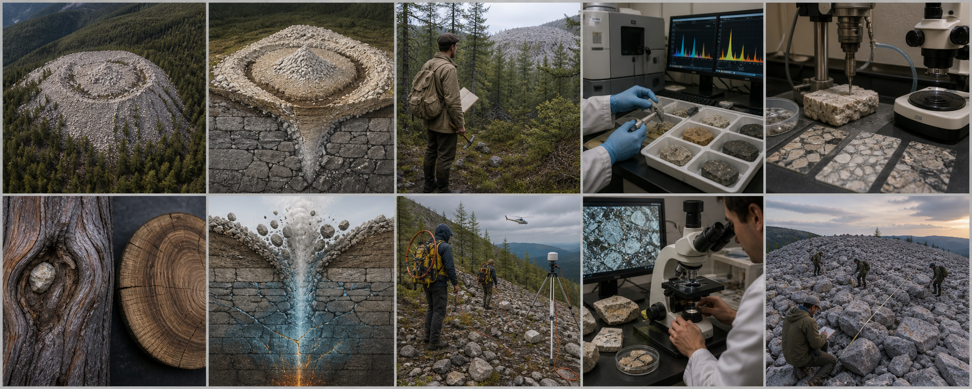
Patomskiy is a pale debris cone on a forested slope, not a broad circular depression. Its ring, inner hollow, and central mound are the first pieces of evidence.
A cone hidden inside the word “crater”
Patomskiy lies in the Bodaibo district of Russia's Irkutsk region, within the Patom Highland. Geologist Vadim Kolpakov encountered it during regional fieldwork in 1949. The site later acquired several names, including Kolpakov's Cone. “Crater” became the durable label, and the label quietly supplied a cause before measurements had supplied one.
The mapped structure is roughly 120–130 by 150–160 meters across at its base. Because it sits on a mountain slope, the apparent height varies around the rim: published measurements place the ring swell roughly 10–12 meters above the upslope side and as much as 35–38 meters above the downslope side. The outer talus is steep, commonly about 33–40 degrees. At the top, a ring roughly 80 meters across encloses a hollow 12–15 meters deep, and a younger-looking central mound rises inside it.
Those dimensions matter less than their direction. A conventional hypervelocity impact excavates a transient cavity, overturns and ejects target layers, shocks minerals, and leaves a depression bounded by a comparatively low rim. Patomskiy is instead a steep construction of loose local debris. The ratio between width and relief resembles an endogenous cone more than a fresh impact basin.
A reconstruction of the mapped architecture: early and late ring swells, an annular trench, a central mound, and fractured carbonate country rock below.
The structure was not made in one instant
Geological mapping by expeditions in 2006 and 2008 divided the cone into parts that differ in weathering, lithology, and relative age. The early ring contains deeply weathered limestone together with occasional sandstone and schist blocks. A later ring is dominated by fresher massive crystalline limestone. A shallow trench separates elements of the ring structure. The central mound, built from minimally weathered limestone, appears to be the youngest surface component.
This sequence is one of the strongest arguments against a single impact. An impact can produce complicated zones, but its excavation and deposition are linked to one brief energy release. At Patomskiy, the early ring had time to weather and accept vegetation before later movement disturbed the site. The central mound completed the architecture after the principal cone already existed.
The cone also exposes rocks from different levels. Most debris is Mariinsk Formation limestone, but sandstone and schist occur in diagnostic places. The pattern is not a random splash of mixed target rock. It is a staged delivery system, apparently controlled by ring and radial fractures.
| Observed zone | Physical character | What I infer |
|---|---|---|
| Outer talus | Loose, steep limestone debris extending into the forest | Material was lifted and deposited, then modified by ongoing rockfall and weathering |
| Early ring swell | More weathered limestone plus sandstone and schist blocks | An older eruptive or uplift episode accessed more varied levels |
| Late ring swell | Fresher massive crystalline limestone | A later event brought up a different and less-weathered parcel |
| Central mound | Very fresh massive limestone; youngest trees | Final uplift or deposition occurred after the ring was established |
Kolpakov's 1949 encounter is reconstructed here as a field observation, not a legend: a geologist, a map, a hammer, and an unexpected limestone cone.
The discovery story, stripped of later folklore
Kolpakov's initial meteorite idea was understandable. In 1949, an isolated circular feature in Siberia naturally evoked impact, especially when no active volcano stood nearby. Later versions connected it to the 1908 Tunguska event or imagined an exceptionally dense body buried far beneath the cone. Those proposals solved the lack of a recovered meteorite by placing it deeper, but that move also made the hypothesis harder to test.
S. V. Obruchev objected early. He suggested that gas or steam could have escaped from depth along a weakened tectonic zone. Other proposals followed: a volcanic vent, a nascent kimberlite pipe, a cryogenic structure, underground combustion, and impact. The list grew because the site was remote and the early evidence sparse, not because all explanations fit equally well.
I do not regard the death of a proposal as a failure of the investigators who first framed it. Kolpakov gave science a visible target. The 1963 Academy of Sciences expedition collected the first integrated observations. Later helicopter-supported campaigns brought geochemistry, petrography, dendrochronology, and electromagnetic sounding. The history is a progressive narrowing of possibilities.
The stones contain no convincing celestial passenger
A meteorite hypothesis should predict more than a circular outline. Investigators looked for chemical enrichment in nickel, cobalt, chromium, iron, and related elements; for meteoritic Fe–Ni minerals; for shock deformation; and for impact melt. The studied samples did not produce that package.
In the 2008 geological and geochemical study, compositions of crater limestone remained characteristic of local carbonate rock. Sandstone and schist blocks inside the cone were not enriched in the suite expected from common meteoritic material. Some were depleted in nickel relative to comparable country rock. No sample required an extraterrestrial component.
Absence has to be used carefully. A small stony object can weather, and an impact into complicated terrain need not preserve every textbook feature. Yet Patomskiy asks the impact model to explain several absences at once—no identified projectile, no persuasive meteoritic geochemical anomaly, no documented shock-metamorphic assemblage, and morphology built in separate stages. The cumulative problem is stronger than any single missing signal.
Rock trays and instrumental spectra replace resemblance with measurement. Limestone, sandstone, and schist can be compared with nearby country rock element by element.
The positive signal is alteration by fluid
Rejecting an impact does not explain the cone. The constructive evidence comes from the rocks' mineralogy and chemistry. Terrigenous blocks within the debris show carbonatization: carbonate minerals fill spaces and replace parts of pre-existing sandstone and schist. Fine pyrite occurs in fractures. Calcium, strontium, and barium can be enriched relative to unaltered equivalents. Reduced gases were detected in fluid studies, and sulfur is more concentrated in some late-stage carbonate material.
The decisive 2015 study added stable isotopes. Oxygen-isotope values in limestone from the debris cone are, on average, about 6.5 per mille lower than those of unaltered Mariinsk Formation limestone cited by the authors. Carbon and strontium isotope ranges remain compatible with the regional Upper Riphean carbonates. In plain language, the rock is still local limestone, but its oxygen system was shifted through interaction with hot water.
The authors' modeling placed that interaction above roughly 100°C. This is not evidence that a lava lake filled the summit. It is evidence that heated water or steam moved through carbonate rock before or during disruption. That distinction is essential: a phreatic explosion is driven by expanding water, even when magma never reaches the surface.
Calcite, fractures, fluid pathways, and isotope measurement provide a thermal history. The result points to heated water acting on local limestone.
The trees turn one eruption into a sequence
The larches are not decoration around the geological evidence. They are instruments that began recording after surfaces stabilized. Researchers counted and cross-dated annual rings, examined abnormal growth, and compared trees on the cone with older trees nearby. The absence of older living trees on a deposit gives a minimum age for that surface; damage in a precisely dated ring can identify a later disturbance.
The newest synthesis places initial cone formation in the late fifteenth or early sixteenth century. Trees now growing near the cone are younger than the oldest regional larches, while a generation approximately 400–480 years old follows the early disturbance. This is far older than the 1908 Tunguska explosion and ends the proposed direct connection.
Then the rings record another event. In 1841–1842, trees near the northern margin experienced root disturbance, stem damage, bending, and compression wood. Rock fragments were reportedly trapped in injured trunks. Sparse larches on the later ring are only about a century old in the cited sampling, while the oldest tree observed on the central mound was extremely young when measured. Additional wood chemistry showed elevated strontium during a period of renewed activity in the 1850s.
The exact correspondence between every ring anomaly and every mapped deposit deserves caution. Trees react to slope movement, rockfall, snow, and wind as well as explosions. But the combined pattern independently supports long-lived, episodic construction. A one-second impact cannot begin around 1500 and return to reshape roots in 1841.
A healed impact scar, compression wood, bent growth, and a cross-dated ring disk preserve the nineteenth-century disturbance without turning every narrow ring into an explosion.
What a phreatic explosion would have done
I reconstruct the mechanism from the evidence outward. Fractures opened a path through ancient carbonate strata. Water occupied part of that fractured system. Heat arrived from depth—possibly associated with a small magmatic intrusion, possibly through decompression of an already heated hydrothermal reservoir. Pressure kept some water liquid above its normal boiling point.
When the confining pressure dropped, a portion flashed to steam. The enormous expansion fragmented the overlying limestone and drove debris upward. Repeated pulses exploited the same damaged conduit, building a steep cone rather than excavating a broad bowl. Between pulses, rubble settled, surfaces weathered, and larches colonized stable ground. Renewed pressure later fractured and lifted fresher limestone, formed the younger ring, disturbed trees, and left the central mound as the last conspicuous surface expression.
This is a phreatic model, not a claim that investigators found a conventional volcanic pipe filled with erupted lava. The visible cone is overwhelmingly country rock. Heat and fluid are the agents; limestone is the payload.
A restrained process reconstruction: heated groundwater flashes to steam in fractured limestone, expands, and lifts local debris without a surface lava eruption.
The underground witness: resistance, not a buried meteorite
In August 2010, geophysicists deployed audio-magnetotelluric instruments across difficult forested terrain. The method measures natural variations in electric and magnetic fields and converts them into a resistivity model. Twenty-one AMT sites and several longer-period measurements were arranged along a profile about 4.3 kilometers long, with average station spacing near 200 meters.
The two-dimensional inversion imaged a steeply dipping high-resistivity body beneath the cone, bounded by more conductive, fractured zones. The model extended to several kilometers depth. This structure cuts across the folded Proterozoic host sequence in the interpretation published by the survey team.
The anomaly strengthens an endogenous origin because it identifies disrupted vertical architecture instead of a compact metal object resting beneath the summit. Yet the authors were explicit about a limitation: their section did not reveal a clear magma conduit. Complicated three-dimensional geology also means one profile cannot settle every structural question. More crossing profiles and ultimately drilling would be more diagnostic.
The 2010 survey required portable coils, electrodes, precise orientation, and foot transport. Its result was a resistivity section, not an X-ray photograph of a hidden object.
Testing the rival explanations against all four witnesses
| Hypothesis | What it explains | What it fails to explain well |
|---|---|---|
| Hypervelocity meteorite impact | Initial visual impression of a circular feature; abrupt energy source | Upbuilt steep cone, staged zones, late tree disturbance, no persuasive projectile chemistry or shock package |
| Ordinary magmatic cinder cone | Volcano-like geometry and endogenous geophysics | Visible cone consists mainly of local limestone, not erupted scoria or lava; no clear conduit imaged |
| Kimberlite pipe | Deep, violent ascent through a central vent is conceptually possible | No diagnostic kimberlite, mantle xenolith suite, or diamond-bearing pipe material has been demonstrated |
| Cryogenic pingo-like process | Permafrost, water, pressure, and uplift can form mounds | Hot-water isotope alteration, mineralization, staged ejecta, and deep structural evidence require more than simple freezing expansion |
| Phreatic explosion in a faulted hydrothermal system | Local-rock debris, hot-water alteration, repeated construction, fractures, and endogenous geophysics | Exact heat source and detailed conduit geometry remain unconfirmed without deeper sampling |
Under the microscope, ordinary fractured carbonate is informative. The missing shock melt and meteoritic metal are part of a cumulative case, not proof by themselves.
My verdict: solved at the level of process, open at the level of plumbing
I judge the meteorite explanation to be effectively displaced by the combined evidence. Patomskiy is not the scar of the Tunguska body, not a recent extraterrestrial impact hidden beneath a limestone hat, and not a feature that requires unknown technology. The cone grew from below through multiple disturbances.
The strongest current reconstruction is a phreatic explosion—or a series of steam-and-gas eruptions—within fractured carbonate rocks. Its case rests on agreement among independent records: upward depositional morphology, sequential geological zones, hydrothermal mineral and isotope signatures, tree-ring chronology spanning centuries, and a vertical geoelectric disturbance.
I stop short of calling the entire mystery closed. “Deep fluids” can become a verbal drawer into which several mechanisms are placed. The 2015 isotope model permits heated water to be triggered either by magma emplacement or by faulting and decompression of hot, water-bearing rock. The 2010 AMT model favors an endogenous disturbance but does not show an unmistakable magma channel. No deep core passes from the central mound through the full anomaly.
The next expedition should drill a timeline, not hunt a monster
A decisive borehole would begin outside the structure, cross the ring swell, and continue beneath the central mound. Continuous core could test whether alteration temperature and fracture density increase downward, whether breccia clasts record repeated pulses, and whether intrusive material exists below the reach of surface mapping.
Three-dimensional magnetotelluric coverage would determine whether the high-resistivity body is a narrow pipe, tilted fracture stockwork, dry carbonate block, or more complex combination. Seismic refraction and passive monitoring could constrain voids and active cracking. Noble-gas and stable-isotope analyses of sealed fluid inclusions could distinguish crustal water from a deeper volatile contribution.
The surface chronology also deserves refinement. Every dated tree should be tied to centimeter-scale topography and a mapped deposit. Radiocarbon dating of buried organic material beneath separate debris units could provide independent maximum ages. Cosmogenic exposure dating may be difficult on unstable carbonate rubble but could be tested on suitable, securely positioned clasts.
The useful future is methodical: map each block, tie samples to deposits, image the subsurface in three dimensions, and recover a continuous core through the hidden plumbing.
Why the cone still deserves the name mystery
Patomskiy demonstrates how a mystery can survive after its most dramatic answer has failed. The object is not less remarkable because it is terrestrial. A young, episodically active, steam-driven cone built from ancient limestone in a non-obvious volcanic setting is a rare geological event. Its landscape is a record of pressure changing phase, rock changing position, and trees turning disturbance into time.
The aerial photograph remains powerful, but it no longer controls my conclusion. The cone's four witnesses agree on the direction of travel: material and energy came upward. What they have not yet named is the exact source that heated the water and kept the system alive across centuries. That question belongs beneath the central mound, where the next core—not the next legend—should go.
Sources and research trail
- Antipin and Fedorov, “The Origin of Patom Crater, East Siberia, from Geological and Geochemical Data,” Doklady Earth Sciences 423A (2008) — dimensions, staged morphology, petrography, chemistry, and the endogenous argument.
- Antipin, Pokrovskii, and Fedorov, “Formation of the Patom Crater by Phreatic Explosion,” Lithology and Mineral Resources 50 (2015) — oxygen, carbon, and strontium isotopes; hot-water alteration; phreatic model.
- Voronin et al., “The Age of the Patom Crater: Dendrochronological and Biogeochemical Investigations” — initial dating, the 1841–1842 tree disturbance, later strontium signal, and multievent interpretation.
- Antipin et al., “The New Data on the Origin of the Patom Crater,” Doklady Earth Sciences 440 (2011) — deep-fluid interpretation and staged formation.
- Ermolin and Ingerov, “Results of AMT Survey at Patomsky Crater,” 73rd EAGE Conference (2011) — field design, resistivity profile, vertical anomaly, and acknowledged limits.
- Siberian Branch researchers, “Patom Crater — Terrestrial or Celestial?” Science First Hand — expedition history, mapped zones, tree evidence, analytical methods, and accessible synthesis.
- Priroda, September 2008 issue — Russian-language expedition report with geological structure, chemical analyses, and dendrochronological observations.
- Siberian Branch of the Russian Academy of Sciences: report on the Patom Crater 2010 research conference — multidisciplinary expedition context and the shift away from impact.
Image note: all ten visuals are original editorial reconstructions. The 1949 discovery and subsurface phreatic scene illustrate evidence-based possibilities rather than photographed moments; the laboratory and geophysical panels depict the published methods without reproducing copyrighted figures.